From downtown Twin Falls
From Main Ave at Shoshone St, take Shoshone St one block northeast and turn left onto 2nd Ave N (US 30). Turn left onto Addison Ave (US 30 and US 93 Business), then turn right (north) onto Martin St. After about 0.1 mile, turn left (west) onto Shoup Ave W. The east building, 608, is right there on the north side. It is about 1.6 to 1.7 miles by car, depending on direction.
From I-84 and the Perrine Bridge
Take I-84 Exit 173 and follow US 93 south across the Perrine Bridge. Turn west onto Pole Line Rd W, turn left (south) onto Washington St N and then right (west) onto Shoup Ave W. The campus is about two thirds of a mile ahead on the right. From the Perrine Bridge it is about 4.2 miles, and from Exit 173 about 7.3 miles.
From the College of Southern Idaho and the Magic Valley Mall
From the College of Southern Idaho, take North College Rd to Washington St N, turn south, then turn right (west) onto Shoup Ave W. That is about 2.6 miles. From the Magic Valley Mall, follow Pole Line Rd W west to Washington St N, turn left (south) and turn right onto Shoup Ave W, about 3.9 miles in all.
From Blue Lakes Blvd and the east side of town
Drive west on Addison Ave W (US 93 Business), turn right (north) onto Martin St and left (west) onto Shoup Ave W. From Blue Lakes Blvd at Addison Ave it is about 1.8 to 1.9 miles. From the Magic Valley Regional Airport it is about 9 miles by way of Blue Lakes Blvd S and 2nd Ave (US 30).
Public transit
Public transit in Twin Falls is Ride TFT, a service of the City of Twin Falls. Its website describes it as on-demand microtransit: shared rides that you book in its app or by phone, rather than a bus on a set route. Check the app for pickup and drop-off at 608, 664 or 676 Shoup Ave W.
Walking and cycling
From Main Ave at Shoshone St in downtown it is about 1.6 miles on foot, roughly 35 minutes, along Main Ave N and then Shoup Ave W. By bike the route measured about 2.8 miles: Shoshone St S, the Olde Town Parkway path, Morrison St and Martin St, then Shoup Ave W.
The Rock Creek Trail passes about 500 feet west of the west building, 676.
Parking
Paved parking areas lie beside and between the buildings, including on both sides of Halsted St. At 676, parking is on the south side of the building and behind it to the west. TF Handy Wash at 664 says on its own website that there is free parking right outside.
Landmarks on the way
Landmarks are public places and streets you can see from the road.
- Perrine Bridge, if you come from I-84 or the north.
- Baxter's Park on Shoup Ave W, about 0.4 mile east of the campus, if you come along Shoup Ave W from Washington St N.
- Addison Ave W (US 93 Business), the main road one block south of Shoup Ave W.
- Martin St, the cross street at the east end of the campus, beside the east building.
- Halsted St, the street between the middle and west buildings.
If your map app sends you to the wrong building
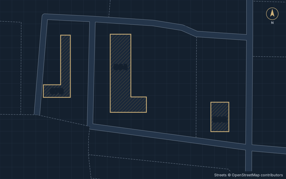
Search by street number and suite, not by business name. 608 is the east building beside Martin St. 664 is the middle building, just east of Halsted St. 676 is the west building, across Halsted St.
Some map apps place a 676 listing on the 664 building. Suite 14 at 676 is one of them. If the app puts you at the middle building but your address says 676, keep going west across Halsted St.
Getting there
608, 664 and 676 Shoup Ave W, Twin Falls, ID 83301
On the north side of Shoup Ave W, from Martin St on the east to just west of Halsted St, with Clouchek Ave behind the buildings. The east building is 608, the middle building is 664 and the west building, across Halsted St, is 676.
Questions and answers
How do I get to West Shoup Campus from I-84?
Take Exit 173 and follow US 93 south across the Perrine Bridge. Turn west onto Pole Line Rd W, left onto Washington St N and right onto Shoup Ave W. The campus is about 7.3 miles from the exit by car.
Can I get to Shoup Ave W by public transit?
Yes, with Ride TFT, a service of the City of Twin Falls. It is on-demand microtransit, booked by app or phone, rather than a bus on a set route.
Can I walk or bike from downtown?
Yes. It is about 1.6 miles on foot from Main Ave at Shoshone St and about 2.8 miles by the bike route measured on October 13, 2026.
My map app put me on the wrong building. What now?
Search by street number and suite. 608 is the east building beside Martin St, 664 is the middle building and 676 is the west building across Halsted St. Some map apps place a 676 listing on the 664 building.